Hperdimensional Katrina – Scientific Evidence and Hurricane Rita Update
As we watch another monster storm Hurricane Rita bear down on the Texas/Louisiana Coast — the second catastrophic disaster to hit this region in only three weeks (!) — we have a major new development to report in our on-going Hyperdimensional Katrina Investigation:
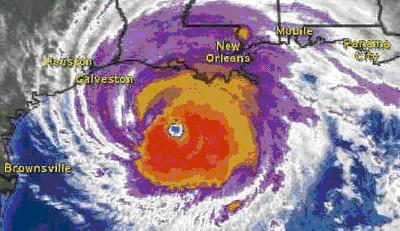
This sequence of New Orleans’ NEXRAD radar data (above) is in our opinion (and that of other experts who have now looked at it our behest …) a proverbial “smoking gun”–
Strongly indicating now that Hurricane Katrina was, in fact, an artificially manipulated hurricane — and … specifically targeted for the City of New Orleans!
The startling evidence supporting this preliminary confirmation lies in a frame-by-frame analysis of this official National Weather Service “radar loop.”
* * *
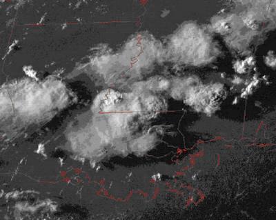
The first thing one notices in looking at these frames, are the bizarre, extraordinarily regular “vorticular patterns” marching across the image (below) — slowly rotating across the field of view in the span of the 18 minutes represented by the sequence. At first glance, this geometry could easily be mistaken for an image of the slowly rotating “feeder bands of rain” in the fully-developed hurricane itself ….
Until … one looks closer at the DATE of this particular NEXRAD radar image sequence:
August 17, 2005 — fully 12 days BEFORE Katrina hit New Orleans!!
Obviously, then, this official National Weather Service radar data CANNOT be from the landfall of Hurricane Katrina … which didn’t come ashore in southern Louisiana until the wee hours of August 29th!
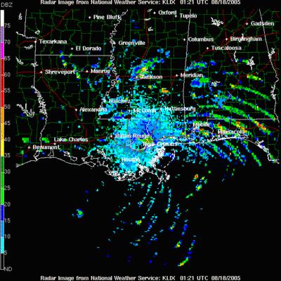
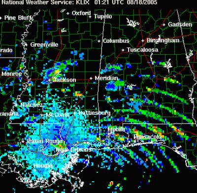
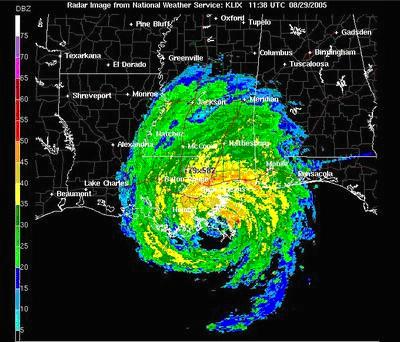
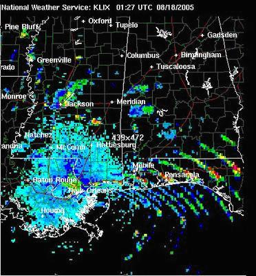
In fact, here’s what the official radar loop (below) of Katrina’s actual landfall on the 29th, from the same NEXRAD station, looked like:
So, what makes the loop from the 17th — twelve days earlier — so unusual …?
This!
This image (below) is the last pre-sunset GEOS visual satellite image of the Louisiana area from the same day as the New Orleans’ radar “anomaly” — August 17th.
As you can see, it reveals a few thunderstorms situated to the north and west of New Orleans the City … but in the area northeast of the City — where those peculiar “radar bands” are located in the close-up — there are no clouds or precipitation at all!
Here’s the visual close-up (below); notice all that TOTALLY CLEAR AIR to the east of the City [located between Lake Pontchartrain (the red oval above the words “New Orleans”) and the top of the “boot” below it, representing the Mississippi delta extending out into the Gulf of Mexico]–
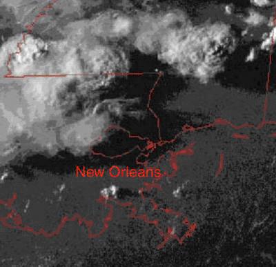
Right where those peculiar radar bands are the heaviest (below)!
Just what the hell is going on!?
Radar images on the National Weather Service NEXRAD image loops are created by transmitted radar energy (from the radar antenna) being reflected back to that same antenna, as a function of azimuth (a 360-degree position, relative to the transmitter). The NEXRAD system “refreshes” these images every 6 minutes — revealing precipitation (rain, or hail or snow) within hundreds of miles of the antenna. Sometimes, when birds are migrating … or insects are swarming in the Spring … the radar system can detect echoes from objects OTHER than raindrops or snowflakes … but that is very rare.
In this case, two highly patterned, incredibly regular, slowly-rotating “vortices” — one northeast of New Orleans, the other to the south, and in TOTALLY CLEAR AIR! — are reflecting strong echoes BACK to the NEXRAD antenna … when there’s NOTHING suspended in that air for the radar beam to be reflecting from!!
Totally inexplicable … by any standard meteorological measure.
And, in case you have any remaining doubts about the truly anomalous nature of this August 17th New Orleans’ radar loop, here (below) is a simultaneous infrared series of GEOS satellite images from UNISYS (a commercial weather corporation, offering National Weather Service data to its clients) of the same area … and covering the same time period (note the time code at the top-right of the graphic).

As can be seen, clouds (the bright areas — and their associated precipitation) are totally missing from this eastern and southern region … in the same time frame and region covered by the mysterious radar loop!
Yet, the anomalous “radar bands” of August 17, 2005 persist … centered on New Orleans.
Just like a giant “bulls eye” was somehow being painted on the Crescent City … 12 days before Katrina struck.
* * *
That, in fact, is exactly what our “hyperdimensional model” for Hurricane Katrina is proposing: that what we are seeing in this extraordinary radar sequence …. is the standard NEXRAD radar signal being — somehow — reflected back from the clear air over and around New Orleans … air which has somehow been made “radar reflective” by the application of an otherwise invisible “energy” signature … from somewhere.

While the precise nature of this anomalous “reflection mechanism” is currently unknown — without further information from other sensor systems — possibilities range from “actual ionization of the air” itself (making it more electrically conductive — and thus radar reflective), to equally anomalous “wavelike” changes in the density of the air within the rotating radar beam ….
In the HD Model, it is this “HD imprinting” of New Orleans, by this impossible (in current physics) “energy vortex signature” which … 12 days later … literally attracted Hurricane Katrina right to New Orleans … exactly like a homesick homing pigeon!
By any current physics, such “imprinting” of an entire geographical location is impossible.
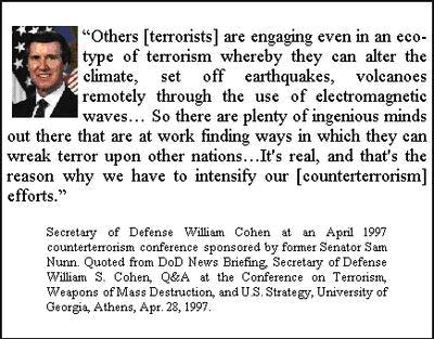
But, isn’t this type of extremely sophisticated “climate control technology” precisely what former Secretary of Defense, William Cohen, tried to warn us about … back in 1997!?
And then, there is the recent theoretical work of physicist, Lt. Col. (US Army — retired) Thomas Bearden — who, for decades, has maintained that such extremely sophisticated “weather modification technology” actually exists, based on a deliberate concealment of some critical laws of physics … which were suppressed over a hundred years ago!
However, in this entry to the “Captain’s Blog” — as opposed to any “theory”– we have now been able to present unequivocal physical evidence … the official NEXRAD radar signatures of August 17th … which dramatically attests that “something,” definitely “impossible” by all known current physics, was leaving an easily detectable radar signature in clear air over the City of New Orleans, on the evening of August 17th ….
Something which … 12 days later … “attracted” the worst regional hurricane disaster in the history of these United States.
What that “energy signature” ultimately represents MUST now be explained … lest whomever is actually using this “secret” technology, decides to strike again ….
* * *
For those who might wonder how we acquired this extraordinary data (which has since been predictably erased from the official NEXRAD record), we must pay homage to a small and unsung band of pioneers who have created the highly arcane field of “radar anomaly research.” With site names like “cyberspaceorbit.com,” “flashradar.com” and “radaranomalies.com,” the investigators maintaining these sites have accumulated a remarkable archive of totally puzzling radar signatures, seen on both civilian and military radars across the entire United States … over the past seven years.
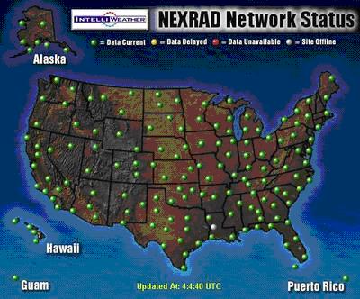
Beginning in 1998, the first of these persistent (and to this day, still officially unexplained) bizarre radar signatures began appearing on the national network of 155 official National Weather Service radar stations (below).
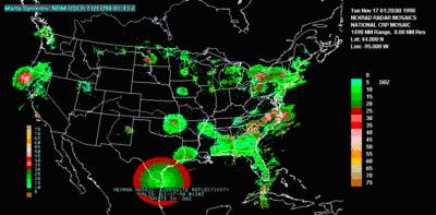
Utilizing this official NEXRAD data, this auxiliary network of amateur “anomaly hunters” made available to non-specialists across the Internet these highly anomalous radar signatures — such as this example, seen in southern Texas in November of 1998 (below):
It is the hope of those of us at Enterprise who have quietly pursued this research since 1998, as well as these dedicated specialists in this almost unknown field cited above, that by posting the truly bizarre “vortex radar anomaly” captured by the NEXRAD network over New Orleans on the evening of August 17th, 2005, someone “in the know” will be further inspired to release MORE crucial data of this type.
One thing seems clear, even at this early stage of our investigation:
Whatever formed this extraordinary radar signature, captured by the NEXRAD network on the 17th, cannot be considered, by any means, a “natural meteorological phenomenon.” Nature does NOT create — and in totally clear air — a set of slowly rotating “ionized vortices” … capable of reflecting radar energy across literally hundreds of miles ….
The distinct possibility that this was, in fact, some kind of “hyperdimensional homing beacon” — specifically designed by “someone” to guide Katrina to a catastrophic landfall at New Orleans just eleven days after this signature first appeared — is thus a scientific hypothesis we feel worthy of further serious investigation … and consideration.
NEW Addendum
A startling overnight microwave radiometer loop of Rita’s approach to the Texas Coast, discovered by Kent Steadman of http://www.cyberspaceorbit.com/, reveals a bizarre, real-time “electronic signature” for Rita!
![]()
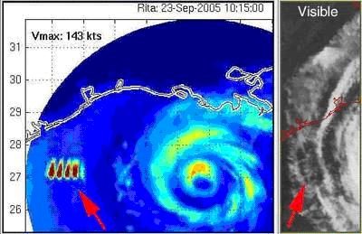
Positioned off the Coast south of Galveston Bay — where the hurricane was projected by the National Weather Service for several days to initially make landfall — the unique “thermal microwave signature” (a MIMIC image, from the University of Wisconsin’s “Cooperative Institute for Meteorological Satellite Studies”) appears to be some kind of “atmospheric side-effect” of an attempt to potentially create a last-minute “HD electronic fence” — designed to push Rita north and east as it approached the Coast … and thus to prevent it from entering the Bay.
NEW: 9/26/05
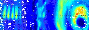
Note, particularly, the latest composite image (above) that Kent (cyberspaceorbit.com) has now posted on his website:
A side-by-side comparison of the microwave thermal “rainfall” image (left), AND a visual GEOS satellite image (right).
The arrow indicates (on the left) the anomalous MIMIC microwave 5 IR “geometric” signatures — indicating that “something” is creating a massively increased amount of rain … and in a highly geometric pattern … in this section of the outer rainbands of the hurricane. The visual satellite image on the right (second arrow) indicates that — whatever is being attempted — seems to actually be working: the level of visible cloud cover in this region of the storm has definitely been reduced … indicating that the water vapor and aerosols there have been dramatically rained out!
Was this a coordinated effort — via some kind of “HD technology” — to selectively condense the water in this region of the storm, thus causing a release of latent heat and a massive disruption of its overall rotation on one side … and a consequent decrease in total category wind velocity … and a “turn to the north?”
While obviously speculation at this point, in fact, Rita DID decrease in this timeframe — from a Category 4 to a Category 3 — before turning slightly north, just hours before making landfall … thus sparing Galveston, Houston and a huge swath of the critical Gulf Coast refineries and chemical plants — which produce more than 25% of the Nation’s gasoline supply — from major wind and water damage ….
New: 9/26/05
After Rita moved inland, forecasters were essentially unanimous in predicting that the remains of a greatly weakened tropical depression Rita would “stall out” over northeastern Texas/northwestern Louisiana … and rain … rain … rain …. Over 25 inches of rain were forecast to come out of the resulting stalled “depression” — inevitably creating flash floods far inland, with the distinct possibility of many additional storm casualties.
Some models even had Rita looping BACK south, toward the Gulf … and eventually re-intensifying again into a tropical storm!
Then, “something” happened ….
And the remains of Rita — instead of “stalling out “– caught a passing low … and took off “like another homesick homing pigeon” for New England ….
While this new “anomalous” set of MIMIC images (below) appeared on the University of Wisconsin website.
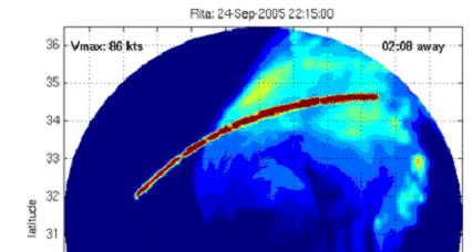
Was this another “electronic fence” somehow triggering more heavy rainfall condensation — designed to “herd” the remains of Rita gently northeast … so she could “catch her final steering current ride” … away from causing more devastation in Louisiana?
Stay tuned.
By Thomas E. Bearden, PhD
Update: Since this article was uploaded in 2005, more attention has been turned to the changing climate and the impact of civilization on this change. Although there is already some known weather manipulation which has been practiced for many years to ensure good field crops, the Hurricane Katrina disaster has data suggesting something other than nature may have triggered this deadly storm.
Skeptically yours,
Mim